

A new web tool used by earthquake experts worldwide is pooling knowledge together to help boost relief efforts in Haiti.
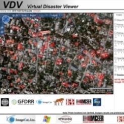
The Virtual Disaster Viewer (VDV) is currently being used by relief agencies operating in Haiti to target emergency food and medical supplies, to prioritise repairs to infrastructure and by allowing planning of reconstruction and recovery to occur.
Each expert is assigned a number of kilometre grids for damage assessment, with hundreds of earthquake scientists and engineers using the VDV to access high-resolution “before and after” satellite and aerial photos of the disaster zone.
The VDV is being funded by the World Bank and co-ordinated by the risk and disaster management company ImageCat.
With the VDV collating satellite and aerial photos down to the level of individual buildings, vegetation to even tents in the temporary encampments, experts can submit detailed assessments about the type and extent of damage caused to key infrastructures such as bridges where refugees are congregating.
The VDV has been used for other situations including the 2009 American Samoa Tsunami and the 2009 Sumatra Earthquake, while it is currently in use by organisations like the British Geological Survey to provide public access to historic disaster datasets.
Please scroll down this page for larger images.